



IMD Cyclone Alert 2026: Andhra Pradesh, Odisha Brace for Heavy Rain and October 28 Landfall
IMD warns of a Bay of Bengal cyclone approaching Andhra Pradesh on October 28, with winds up to 140 kmph and extremely heavy rain in Andhra and Odisha.
 Rajeev
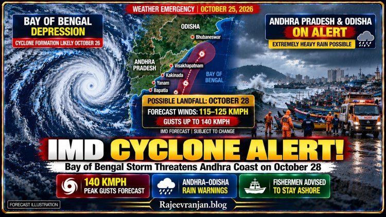

Bay of Bengal Cyclone Threat Grows: Andhra Pradesh Braces for October 28 Landfall as IMD Warns of Extreme Rainfall
From fishing harbours along the Andhra Pradesh coast to farming villages in southern Odisha, communities are preparing for potentially dangerous weather. The latest forecast suggests that a strengthening Bay of Bengal system could become a very severe cyclonic storm before reaching the eastern coastline.
NEW DELHI | OCTOBER 25, 2026
India's eastern coastline is preparing for a potentially dangerous cyclone.
A weather system developing over the Bay of Bengal has intensified into a depression, prompting the India Meteorological Department to issue a pre-cyclone watch for Andhra Pradesh and neighbouring southern Odisha.
According to the IMD's latest forecast, the depression is expected to strengthen further over the next two days before approaching the Andhra Pradesh coast on Wednesday, October 28.
The weather department predicts that the system could cross the Andhra Pradesh and Yanam coasts between Bapatla and Visakhapatnam as a very severe cyclonic storm.
Maximum sustained winds could reach 115–125 kilometres per hour, with gusts of up to 140 kilometres per hour.
The developing storm also threatens to bring extremely heavy rainfall to several coastal districts.
Authorities have begun reviewing disaster-response arrangements, while fishermen have been advised to avoid dangerous sea conditions.
The latest forecast marks a significant escalation from the initial yellow-alert reports that emerged when the system was still a developing low-pressure area.
However, the storm's actual intensity and landfall location will depend on its development over the coming days.
Where Is the Weather System Now?
According to the IMD's October 25 morning bulletin, the depression was located over the east-central and adjoining southeast Bay of Bengal.
At 5:30 a.m., its centre was near latitude 15.3°N and longitude 91.2°E.
The system was approximately:
-
440 km north-northwest of Sri Vijaya Puram in the Andaman Islands.
-
880 km east-southeast of Visakhapatnam.
-
980 km east-southeast of Kakinada.
-
1,080 km east of Machilipatnam.
-
1,150 km east of Bapatla.
The system is forecast to move initially southwards before turning towards the west-northwest.
Meteorologists expect it to intensify into a cyclonic storm by the morning of October 26.
Further strengthening is possible as it moves across the Bay of Bengal.
The latest forecast places the expected landfall along the Andhra Pradesh coast on October 28.
These projections are based on current atmospheric observations and forecasting models. They may change as newer data becomes available.
October 28 Could Be the Most Critical Day
The IMD expects the weather system to undergo several stages of intensification.
| Date | Forecast Development |
|---|---|
| October 25 | Depression expected to intensify into a deep depression |
| October 26 | Cyclonic storm likely to develop over the Bay of Bengal |
| October 27 | System expected to strengthen further into a severe cyclonic storm |
| October 28 | Potential landfall along the Andhra Pradesh coast as a very severe cyclonic storm |
| October 29 | Heavy rainfall and associated impacts may continue in affected regions |
The forecast landfall corridor extends between Bapatla and Visakhapatnam.
Residents should not assume that only locations directly along the eventual landfall point will experience dangerous conditions.
Heavy rain, strong winds and coastal flooding can affect areas outside the storm's immediate centre.
The IMD has warned that rainfall intensity could increase sharply as the system approaches land.
Andhra Pradesh: Extremely Heavy Rainfall Expected
Andhra Pradesh faces the most direct threat from the developing system.
According to the IMD's October 25 warning, extremely heavy rainfall is forecast in coastal Andhra Pradesh on October 27 and 28.
The weather department has also warned of thunderstorms, lightning and strong surface winds.
Districts requiring close attention include Bapatla, Krishna, Guntur, Kakinada, Visakhapatnam, Anakapalli, Srikakulam and Vizianagaram, among others.
The district-level risk varies and may change as the storm approaches.
What Could Happen?
Urban flooding: Intense rainfall could overwhelm drainage systems in low-lying areas.
Damage to vulnerable structures: Strong winds may damage temporary shelters, weak roofs and poorly secured structures.
Agricultural losses: Heavy rainfall and waterlogging could damage standing crops.
Electricity disruptions: Fallen branches and damaged infrastructure may interrupt power supplies.
Transport delays: Waterlogged roads and poor visibility could affect buses, trains and other transportation.
The severity of these effects will depend on the storm's final track, rainfall distribution and local preparedness.
Odisha on Alert: Heavy to Extremely Heavy Rain Forecast
Although the latest projected landfall lies in Andhra Pradesh, Odisha remains exposed to significant rainfall risks.
The IMD has forecast very heavy rainfall in Odisha on October 27.
Extremely heavy rainfall is possible on October 28, followed by further very heavy rainfall in parts of the state on October 29.
Southern Odisha districts, particularly those closer to the Andhra Pradesh border, require careful monitoring.
Areas including Ganjam, Gajapati, Rayagada, Koraput and Malkangiri may face significant weather-related disruption.
Why Odisha Must Remain Prepared
Cyclonic systems can produce extensive rain bands extending far beyond their centre.
Even if the storm crosses the Andhra Pradesh coast, Odisha could experience heavy rainfall, strong winds and localised flooding.
Hilly and low-lying areas may face additional risks from intense rain.
Authorities will need to monitor river levels, drainage networks, vulnerable settlements and transportation routes.
The eventual impact will depend on the storm's movement after landfall.
Yellow, Orange and Red Alerts: What Do They Mean?
One important point for readers is that an IMD warning is not necessarily the same across every district or forecast day.
The department uses colour-coded alerts to communicate different levels of weather risk.
| Alert | General Meaning | Recommended Response |
|---|---|---|
| Green | No significant warning | Continue normal activities while monitoring forecasts |
| Yellow | Watch for potentially adverse weather | Stay updated and exercise caution |
| Orange | Be prepared for potentially severe weather | Review safety arrangements and follow official instructions |
| Red | Take action against dangerous weather | Follow emergency advisories and protective measures promptly |
The earlier yellow-alert framing should not be interpreted as the current warning level for every affected area.
By October 25, the IMD was forecasting extremely heavy rainfall in coastal Andhra Pradesh and Odisha for October 27–28.
Residents should check the latest district-specific warnings rather than relying on older social-media posts.
Fishermen Warned Against Venturing Into the Sea
The developing cyclone presents a particularly serious danger to fishing communities.
As the system intensifies, sea conditions across parts of the Bay of Bengal are expected to become increasingly hazardous.
The IMD has advised fishermen to avoid specified areas of the central Bay of Bengal and waters off Andhra Pradesh and Odisha during the period of expected intensification.
Fishermen already at sea have been advised to return to the coast according to the department's instructions.
Small fishing vessels are particularly vulnerable to strong winds, high waves and rapidly changing sea conditions.
Fishing communities should follow directions from harbour authorities, the Coast Guard and local administrations.
No fishing trip is worth the risk of entering waters covered by an official cyclone warning.
Could the Cyclone Be Named Arnab?
Several news reports have referred to the developing system as the potential Cyclone Arnab.
Arnab is the next available name on the regional tropical cyclone naming list.
The name was contributed by Bangladesh.
However, a depression does not automatically receive a cyclone name.
The system must first strengthen sufficiently to meet the criteria for a cyclonic storm.
As of the IMD observations referenced in this report, the system had not yet reached that stage.
Therefore, referring to it as a potential Cyclone Arnab is more accurate than reporting that a named cyclone has already formed.
Why October Cyclones Can Be Dangerous
October falls within an important period for tropical cyclone activity over the North Indian Ocean.
Warm sea-surface temperatures can provide energy for the development of cyclonic systems.
Favourable atmospheric conditions may allow a depression to strengthen as it moves across the sea.
However, cyclone intensity depends on several factors, including wind shear, moisture and ocean conditions.
The Bay of Bengal has historically produced storms capable of causing extensive damage along India's eastern coastline.
The region contains densely populated coastal settlements, agricultural areas, fishing communities and important transport infrastructure.
This combination makes early warnings and preparedness particularly important.
The present system's forecast intensity warrants attention, but its final strength cannot be known with certainty before landfall.
What Should Coastal Residents Do Now?
Residents in areas covered by cyclone warnings should prepare before conditions deteriorate.
Monitor official bulletins. Use IMD updates and district administration announcements rather than unverified social-media forecasts.
Secure loose objects. Move lightweight outdoor furniture, temporary roofing materials and other unsecured items to safer locations.
Prepare essential supplies. Keep drinking water, medicines, identification documents, flashlights and power banks accessible.
Avoid dangerous sea conditions. Fishermen and boat operators should follow restrictions issued by the relevant authorities.
Know evacuation arrangements. Residents of vulnerable coastal and low-lying areas should identify designated shelters and official evacuation routes.
Stay away from floodwater and electrical hazards. Never approach fallen power lines or attempt to cross rapidly flowing water.
Emergency services should be contacted immediately when life or property is in danger.
Evacuations, where ordered by local authorities, should not be delayed.
What Happens Next?
The next 48–72 hours will be critical.
Meteorologists will monitor whether the depression strengthens into a cyclonic storm as forecast.
Authorities will continue reviewing coastal preparedness and disaster-response capabilities.
Further IMD bulletins should provide more precise information about the system's location, strength and expected landfall.
The most important developments to watch are the cyclone's actual formation, any changes in its predicted path, updated district-wise rainfall warnings and instructions issued to coastal communities.
For now, the strongest message is preparedness rather than panic.
Andhra Pradesh and Odisha Face a Critical Weather Week
The developing Bay of Bengal weather system presents a significant risk to India's eastern coastline.
The IMD has forecast that the depression could intensify into a very severe cyclonic storm before reaching Andhra Pradesh on October 28.
Extremely heavy rainfall is expected in parts of Andhra Pradesh and Odisha during October 27–28.
Strong winds, dangerous sea conditions and possible flooding make advance precautions essential.
However, the storm has not yet completed its expected intensification, and the forecast remains subject to change.
For coastal communities, the coming days are not merely about tracking a cyclone on a map. They are about preparing early enough to protect families, livelihoods and essential services.